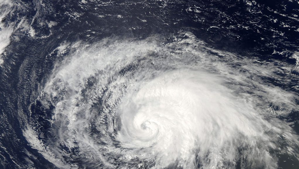
Forecasts for this year’s hurricane season predicted above-average activity with slower, stronger storms. Now that we are nearing the end of what’s been the most active Atlantic hurricane season on record, trends show that experts were right.
The National Oceanic and Atmospheric Administration predicted 13–19 named storms forming in the Atlantic, three-to-six of those being major hurricanes.
As of Nov. 18, this hurricane season, which began on June 1 and ends on Nov. 30, had already produced 31 storms, prompting the use of the Greek alphabet for names.
So far, this season has had nine storms with Greek names: Alpha, Beta, Gamma, Delta, Epsilon, Zeta, Eta, Theta and the latest hurricane, Iota, which made landfall in Nicaragua as a catastrophic Category 4 hurricane on Monday, Nov. 16.
Iota struck Nicaragua with wind speeds of 155 mph, missing Category 5 status by only 2 mph.
2020 marks the second year that the National Hurricane Center has used up the full list of names for the season, the first being in 2005, when 28 tropical or subtropical cyclones were recorded.
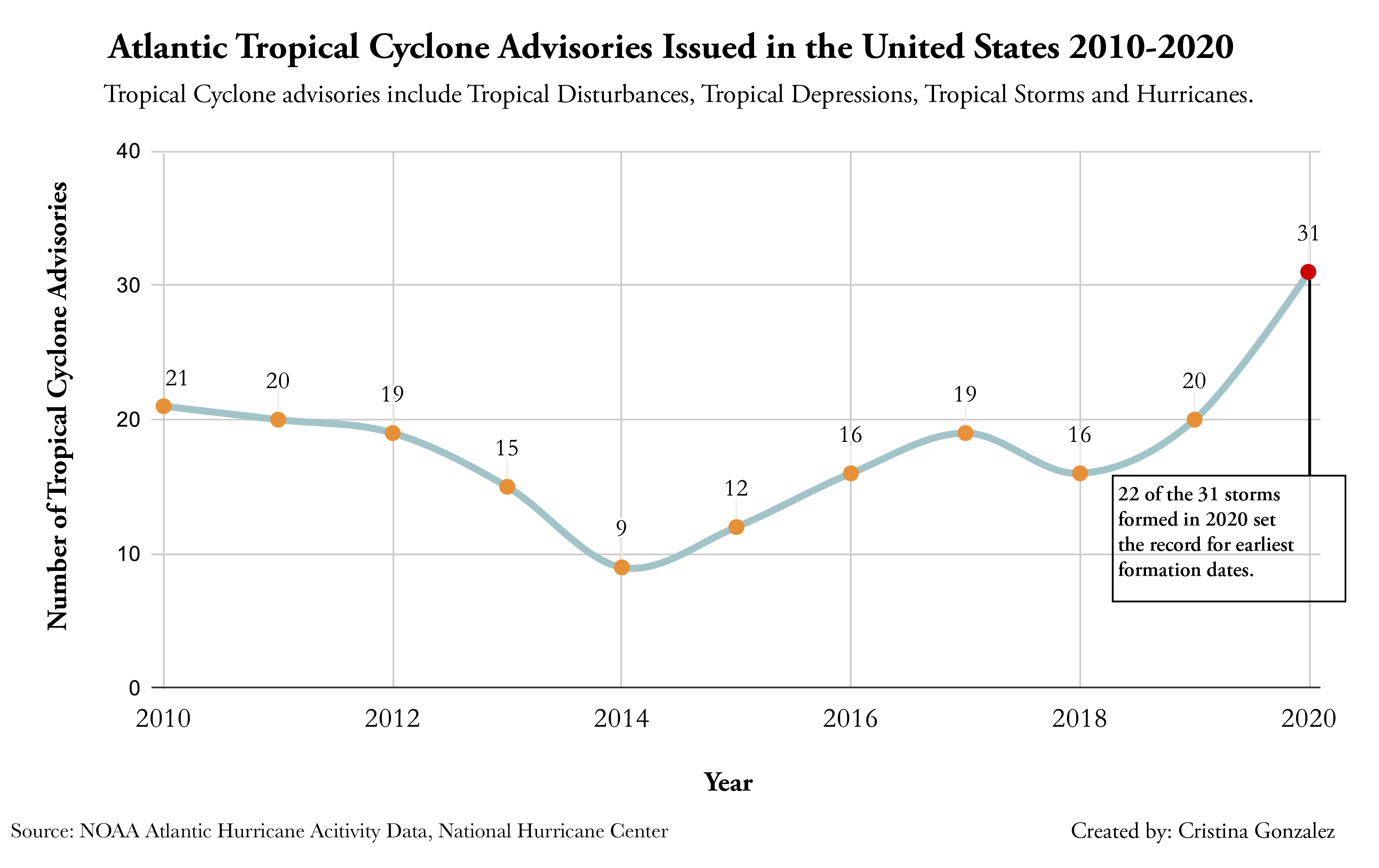
Over the last decade, there has been an increase in the number of tropical cyclone advisories issued in the United States. These advisories include tropical disturbances, depressions, storms and hurricanes.
According to data from the National Oceanic and Atmospheric Administration, 2020 has produced 11 more tropical cyclones than last year and triple the number of storms produced back in 2014.
Twenty-two of the storms had formed by Oct. 5 of this year. That broke records for the earliest formation date.
Typically, the average date for the 9th Atlantic storm to form is Oct. 4. By early October, the total was already 16 storms past that average record.
Due to the effects of climate change and La Niña, sea surface temperatures have been warmer than usual. This, in combination with a lack of wind shear, has created the perfect environment for disturbances to form and survive, meaning more U.S. landfalls.
Hurricane Delta, which hit Louisiana as a Category 2 storm on Oct. 9, broke the record for most landfalls on the continental U.S — a record set back in 1916.
Louisiana continued to get battered with Hurricane Zeta which also made landfall as a Category 2 hurricane on Oct. 29. It was the eleventh tropical storm or hurricane to hit the U.S. this year.
The number of landfalls in the U.S. is at an all-time high. And there is still a week left in the season.
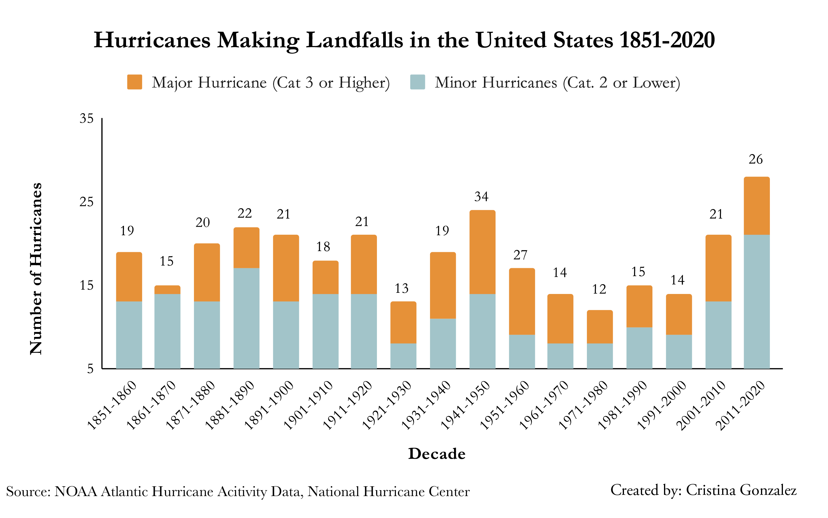
In the last decade, there has been an increase in the number of major hurricanes (Cat. 3 or higher) to hit the U.S.
As of Nov. 18, this decade has seen 26 major hurricanes make landfall, that’s five more storms than the previous decade.
Going as far back as the 1960s, it’s evident that the number of hurricanes, both minor and major, has increased.
The max sustained winds for major hurricanes range anywhere from 111 mph to 157 mph or higher, or what is considered a destructive Category 5 hurricane.
This unprecedented season has had 13 hurricanes form. Before making landfall, Hurricane Iota had reached maximum winds of 160 mph. It is only the second Category 5 hurricane to form within the month of November.
Hurricane Teddy was the earliest-forming 19th named storm of the Atlantic hurricane season, intensifying to a Category 4 storm with winds up to 140 mph.
Compared to this year, 2019 saw a smaller number of storms forming and striking the U.S. However, the max sustained winds for major hurricanes last year were as high and at times higher than the ones formed in this season, so far.
Currently, the National Hurricane Center is tracking a new disturbance that may develop into a tropical depression this upcoming weekend.
For part two of this series, click here.


