
")
")
")
")
")

")
")
")

")
")


")

")


As South Florida journeys through another hurricane season, meteorologists and experts have spotlighted a crucial player in the climatic orchestra: El Niño. This recurring climate pattern, characterized by warmer-than-usual sea surface temperatures in the equatorial Pacific Ocean, holds the potential to shape the season.
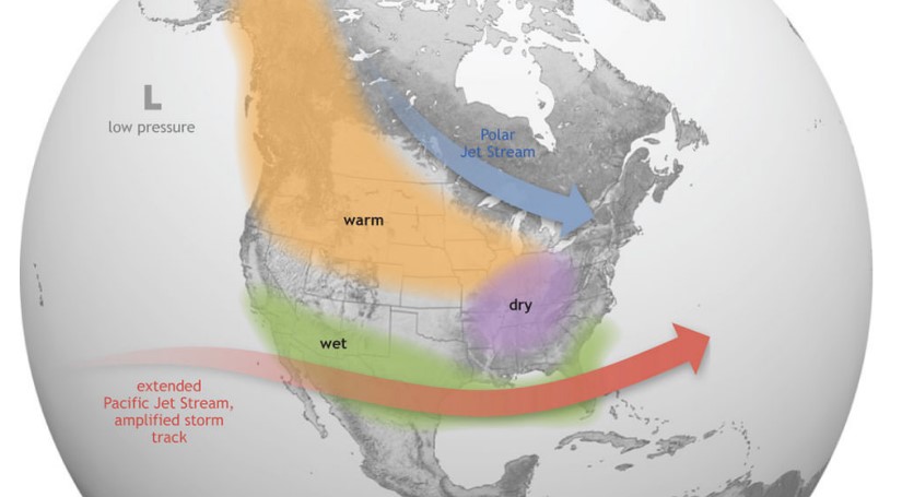
According to the National Oceanic and Atmospheric Administration (NOAA), the United States finds itself in an El Niño phase of the ENSO (El Niño/La Niña Southern Oscillation) cycle, with El Niño conditions prevailing across the equatorial Pacific Ocean.
Understanding the El Niño-La Niña impact on hurricane activity becomes imperative for South Florida, as it can shape the intensity, frequency and paths of potential storms. As coastal communities brace themselves, a heightened awareness of El Niño’s dynamics becomes essential in enhancing preparedness strategies to safeguard lives and mitigate the potential impact of the hurricane season, which runs through Nov. 30.
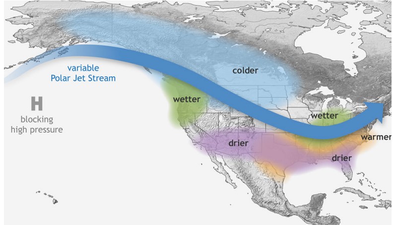
Specific years exhibit significant warmth and higher precipitation levels, known as El Niño, while other years experience notable coolness and lower rainfall, referred to as La Niña.
“The forecast going into this year is like a tug of war,” said meteorologist Erik Salna. “If it were just El Niño going, the NOAA forecast would have had lower numbers. On the flip side, going into this season, we have a battle between El Niño and La Niña.”
Salna, 63, is also the Associate Director at the International Hurricane Research Center at Florida International University and has several years of experience as a broadcast meteorologist, providing continuous live coverage of hurricanes, tornadoes and flooding.
Salna said the NOAA came out with an average forecast because it is still determining which will win this year. Hence, the “tug of war” going on this summer.
But who will win – the sea surface temperatures or the wind shear of El Niño? Well, the key ingredient in El Niño’s potential to safeguard South Florida against destructive hurricanes is – wind.
Salna works closely with FIU’s Wall of Wind, a large-scale wind engineering research facility designed to simulate hurricane and extreme wind conditions. The Wall of Wind consists of a grid of powerful fans that can generate wind speeds up to Category Five hurricane levels.
Salna said El Niño is connected to the Atlantic and the Caribbean because when the waters are warmer than average, there is a high volume of upper-level winds and an increase in wind shear.
Wind shear refers to the change in wind speed and direction over a relatively short distance in the atmosphere. It can occur vertically or horizontally and is commonly associated with fluctuating weather systems.
“Hurricanes do not like wind shear; they like a calm condition above their heads,” Salna said. “When you have a lot of wind turbulence in the upper atmosphere, it caps off hurricane growth and slows them down.”
Hugh Willoughby, American atmospheric and hydrospheric scientist, said El Niño will probably win for the United States and the Caribbean.
“The Atlantic is warmer in high latitudes than any other ocean, so it experiences high amounts of wind shear,” Willoughby said. “Shear is good for people and bad for hurricanes.”
The strong vertical wind shear acts as a barrier, inhibiting the vertical circulation necessary to develop powerful hurricanes. As a result, South Florida is seeing a relatively calm hurricane season with reduced tropical cyclone activity and a decreased threat from significant storms.
“We are most likely not going to experience a disastrous year,” said Willoughby.
Willoughby, 78, studied the nature of tropical storms for over 55 years and has ventured into the heart of over 400 hurricanes and typhoons as a meteorologist representing the federal government. He made major contributions to the Hurricane Research Division of NOAA’s Atlantic Oceanographic and Meteorological Laboratory.
His expertise and experience in the field have earned him a position on the Florida Commission on Hurricane Loss Projection Methodology, where he provides valuable insights into hurricane impacts and insurance matters.
He said if people should be concerned, the La Niña years require more attention; however, preparing is still essential.
“Get ready, but there is no need to be nervous,” Willoughby said.
With reduced hurricane activity, residents have more time to reinforce hurricane and tropical storm protocols. And Salna said the number of storms does not matter, being prepared is what’s most paramount.
“Florida is the hurricane capital of the United States,” he said. “With this state being the third most populous place in the U.S., it is important to live a highly conscious lifestyle taking into consideration the environment in which we call home.”

")
")
")
")
")